
價格:免費
更新日期:2019-06-19
檔案大小:205.9 MB
目前版本:3.12.0
版本需求:需要 iOS 10.0 或以上版本。與 iPhone 5s、iPhone 6、iPhone 6 Plus、iPhone 6s、iPhone 6s Plus、iPhone SE、iPhone 7、iPhone 7 Plus、iPhone 8、iPhone 8 Plus、iPhone X、iPhone XS、iPhone XS Max、iPhone XR、iPad Air、iPad Air Wi-Fi + Cellular、iPad mini 2、iPad mini 2 Wi-Fi + Cellular、iPad Air 2、iPad Air 2 Wi-Fi + Cellular、iPad mini 3、iPad mini 3 Wi-Fi + Cellular、iPad mini 4、iPad mini 4 Wi-Fi + Cellular、12.9 吋 iPad Pro、12.9 吋 iPad Pro Wi-Fi + Cellular、iPad Pro(9.7 吋)、iPad Pro(9.7 吋)Wi-Fi + 行動網路、iPad (第 5 代)、iPad(第五代)Wi-Fi + 行動網路、iPad Pro(12.9 吋)(第二代)、iPad Pro(12.9 吋)(第二代)Wi-Fi + 行動網路、iPad Pro(10.5 吋)、iPad Pro(10.5 吋)Wi-Fi + 行動網路、iPad (第六代)、iPad Wi-Fi + Cellular(第六代)、iPad Pro(11 吋)、iPad Pro(11 吋) Wi-Fi + 行動網路、iPad Pro(12.9 吋)、iPad Pro(12.9 吋)Wi-Fi + 行動網路、iPad mini(第 5 代)、 iPad mini(第 5 代)Wi-Fi + 行動網路、 iPad Air(第 3 代)、 iPad Air(第 3 代)Wi-Fi + 行動網路 及 iPod touch 相容。
支援語言:日語, 英語
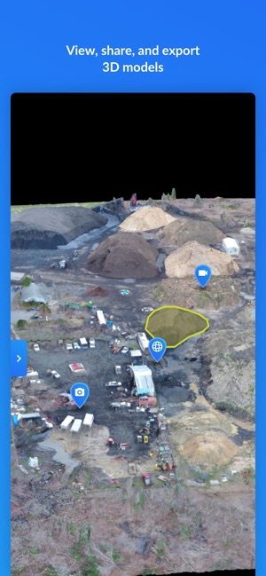
DroneDeploy is the leading cloud software platform for drones, and is making the power of aerial data accessible and productive for everyone. The free DroneDeploy app provides easy automated drone flight and media capture, enabling you to generate, explore and share high-quality interactive drone maps, orthomosaics, 3D models, photos, videos and panoramas directly from your mobile device.
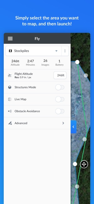
Fly your DJI drone autonomously with just two taps on your iOS device. Quickly process your media with DroneDeploy - even real-time LiveMaps - to generate high-resolution content that you can analyze, annotate and share with others directly from within the app. Extend DroneDeploy’s capabilities and take your analysis to the next level with over 80 apps available for install within DroneDeploy’s Platform App Market.
DroneDeploy is the leading app for aerial reality capture and is trusted by the largest names in construction, solar, energy, agriculture, surveying, mining, insurance, inspection and more. DroneDeploy has empowered users to map and analyze over 40 million acres in more than 180 countries.
Compatible with DJI's latest drones:
- Mavic 2 Pro / Zoom / Enterprise / Dual
- Mavic Pro
- Mavic Air
- Phantom 4 Pro V1 / V2
- Phantom 4
- Phantom 3 Pro / Advanced
- Inspire 2
- Inspire 1 / Pro
- Matrice 100
- Matrice 200 / 210 / 210 RTK V1 / V2
- Matrice 600
Not Compatible with the Following Hardware:
- Spark
- CrystalSky Monitor and CrystalSky Integrated Display
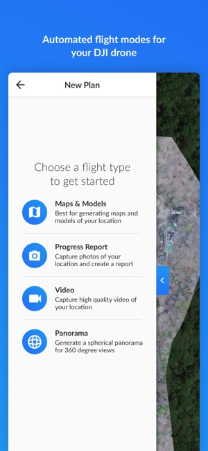
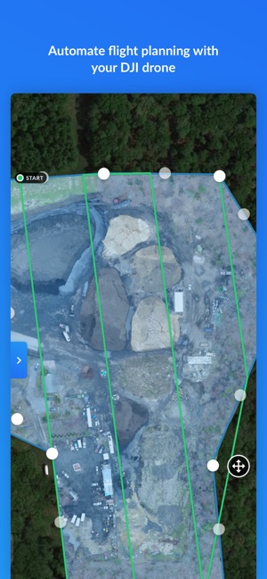
Automate Mapping and Media Flights for DJI Drones:
- Fly and collect aerial data with easy-to-use, reliable software
- Plan and schedule repeatable flights in a few simple steps
- Disable auto-flight and resume control with a single tap
- Fly and map massive areas with high-quality resolution
- Capture imagery with a variety of cameras and sensors
- Film professional quality video autonomously
- Create spherical panoramas all within DroneDeploy
Real-Time Drone Insights with Live Map
- Capture an aerial view of your job site, field, or project immediately
- Render maps and quickly identify areas of interest - no internet or SD card required
- Make decisions and take action in real time without going back to the office
- Visualize temperature range variability and generate thermal maps over large areas
- Share maps with clients, collaborators and analysts in minutes
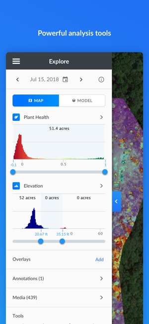
In-Field Data Analysis on Any Device:
- Explore Orthomosaic, NDVI, VARI, Digital Elevation Maps and 3D models
- Measure elevation, distance, volumes, surface area, and roof geometry
- Compare actual conditions to pre-construction designs with built-in tools
- Collaborate with a team through shared maps, annotations, and comments
- Get help when needed with enterprise-ready customer support (paid customers)
Cloud Photogrammetry and Processing on DroneDeploy.com:
- Wirelessly transfer images from the drone to mobile device
- Upload media directly to the DroneDeploy cloud to begin processing
- Get fast and high-resolution results without sacrificing quality
- Create accurate maps and models with ground control points
- Export data in the format you need - JPG, Geotiff, OBJ, XYZ, LAS
Find out more at www.dronedeploy.com
Please join us in improving and discussing the app at http://forum.dronedeploy.com
支援平台:iPhone, iPad